Regional Characteristics
- home
- About Geumcheon
- Regional Characteristics
Geographical Characteristics
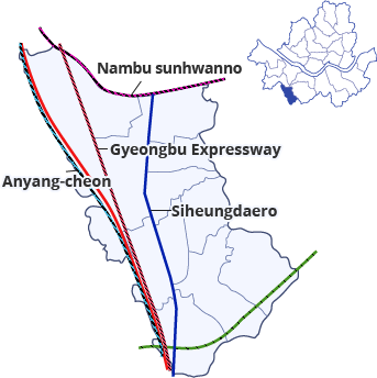
Geumcheon-gu is located on the southwestern tip of Seoul, bordering
Gwanak-gu on the east, Gwangmyeong-si on the west, Anyang-si on the
south, and Guro-gu on the north.
The shape of the area resembles a shoe, and its boundaries with Guro-gu
and Gwanak-gu are divided by the Nambu Beltway, which opened in
1978, stretching out from the east to the west, while Anyangcheon
Stream borders Gwangmyeong-si from the north to the south with the
Gyeongbu Railway running side by side, and soon the Gangnam Beltway
is scheduled to pass underneath this section.
In addition, Siheung-daero runs through the center of our district, con
nected to Gyeongsu Industrial Road, National Route 1, and Seohaean
Expressway, while Seobu Expressway serves as a connecting road
through Siheung Bridge with Gwangmyeong Station (Gyeongmyeong City,
Gyeonggi-do) located nearby, thus functioning as a key traffic hub for
southwestern Seoul.

Regional Economy
Geumcheon-gu is located on the southwestern tip of Seoul, bordering Gwanak-gu on the east, Gwangmyeong-si on the west, Anyang-si
on the south, and Guro-gu on the north.
The shape of the area resembles a shoe, and its boundaries with Guro-gu and Gwanak-gu are divided by the Nambu Beltway, which
opened in 1978, stretching out from the east to the west, while Anyangcheon Stream borders Gwangmyeong-si from the north to the
south with the Gyeongbu Railway running side by side, and soon the Gangnam Beltway is scheduled to pass underneath this section.
In addition, Siheung-daero runs through the center of our district, connected to Gyeongsu Industrial Road, National Route 1, and
Seohaean Expressway, while Seobu Expressway serves as a connecting road through Siheung Bridge with Gwangmyeong Station
(Gyeongmyeong City, Gyeonggi-do) located nearby, thus functioning as a key traffic hub for southwestern Seoul.

Urban Environment
Geumcheon-gu underwent extensive development as a large-scale land adjustment project was carried out in the regions of Doksan and
Siheung to secure residential areas for the Seoul Digital Industrial Complex in the early 1970s. As a result, its land use was divided into
industrial and residential areas, but subsequently, the urban environment became severely deteriorated due to the mixed land use as
small factories became densely populated and housing was built.
Furthermore, military units located over 100,000 pyeong of land in Doksan-dong has caused inconvenience to residents and interfered
with the development of commercial districts, thus hindering the balanced regional development. Therefore, the district is fueling urban
development with primary focus placed on its three commercial areas and living areas in order to improve the efficiency of land use by
adjusting the unreasonable Urban Master Plan and achieving balanced regional development.

